JavaScript is disabled for your browser. Some features of this site may not work without it.
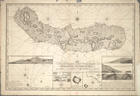
| Título: | Chart of the Island of Saint Michael |
| Chart of the Island of St. Michael | |
| Autor/Colaborador: | Stephenson, John, fl.1786-1800 |
| Data: | 1808 |
| Descrição: | "The Mole & Castle of St. Braz" - Escala ca 1:3200, determinada com o valor calculado 2,90 cm correspondente a "50 Fathoms" ingleses |
| "Plan of the Bason" - Escala ca 1:4700, determinada com o valor calculado 3,90 cm correspondente a "100 English Fathoms" | |
| "A Survey of Villa Franca with the adjacent Island" - Escala ca 1:9900, determinada com o valor calculado 1,85 cm correspondente a "100 Fathoms" ingleses. | |
| Monografia | |
| Levantamento efectuado em Julho de 1806 | |
| Na margem inferior contém insertos os seguintes mapas: "A View of the City of Ponta Delgada taken from the Anchorage, sbewing and Marks, as survyed June 10 th. 1806" - Escala ca 1:11000, determinada com o valor calculado 3,40 cm correspondente a "200 Fathoms" ingleses | |
| Tipo: | material cartográfico, impresso |
| Material cartográfico] | |
| Idioma: | Inglês |
 Acessar o documento na Instituição de origem
Visualizar