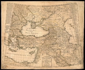
A map of Turkey, Little Tartary, and the countries between the Euxine and Caspian Seas : Including likewise Walakhia, Moldavia & Transilvania; with so much of Poland, the Russian & Persian Empires, as may serve to exhibit the seat of the war, carry'd on of late between the turks and persians, as well as at present between the germans, russians and turks
- Página inicial
- →
- Biblioteca Digital Luso-Brasileira
- →
- BNDigital do Brasil
- →
- Ver item
JavaScript is disabled for your browser. Some features of this site may not work without it.
| Título: | A map of Turkey, Little Tartary, and the countries between the Euxine and Caspian Seas : Including likewise Walakhia, Moldavia & Transilvania; with so much of Poland, the Russian & Persian Empires, as may serve to exhibit the seat of the war, carry'd on of late between the turks and persians, as well as at present between the germans, russians and turks |
| Autor/Colaborador: | Bowen, Emanuel, m.1767 |
| Data: | 1739 |
| Descrição: | aquarelado |
| 46,5 x 51,3cm em f. 51,2 x 62,4 | |
| Assuntos: | Middle East - Maps - Early works to 1800 |
| Oriente Médio - Mapas - Obras anteriores a 1800 | |
| Tipo: | Mapa |
| Idioma: | eng |
 Acessar o documento na Instituição de origem
Visualizar