- Página inicial
- →
- Biblioteca Digital Luso-Brasileira
- →
- BNDigital do Brasil
- →
- Ver item
JavaScript is disabled for your browser. Some features of this site may not work without it.
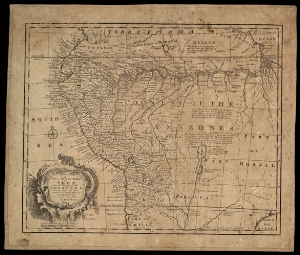
| Título: | A new and accurate map of Peru and the country of the Amazones drawn from the most authentic French Maps e C. and regulated by astronomical observation |
| Autor/Colaborador: | Bowen, Emanuel, m.1767 |
| Data: | [17--] |
| Descrição: | 32 x 42,5cm em f. 40,6 x 48 |
| Assuntos: | Peru - Mapas - Obras anteriores a 1800 |
| Indians of South America - Maps - Early works to 1800 | |
| Brazil - History - To 1822 - Maps | |
| Peru - Maps - Early works to 1800 | |
| Amazon River - Maps - Early works to 1800 | |
| Índios da América do Sul - Mapas - Obras anteriores a 1800 | |
| Brasil - História - Período Colonial, 1500-1822 - Mapas | |
| Amazonas, Rio - Mapas - Obras anteriores a 1800 | |
| Tipo: | Mapa |
| Idioma: | eng |
 Acessar o documento na Instituição de origem
Visualizar