JavaScript is disabled for your browser. Some features of this site may not work without it.
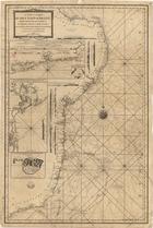
| Título: | <A >new chart of the coast of Brazil from the banks of St. Roque, to the Island of St. Sebastian with the islands and soudings in the offing from the portuguese and dutch draughts, and the journals of the britsh navigators |
| Data: | 1794 |
| Descrição: | Na margem lateral esquerda contém janelas com os seguintes mapas: "The coast of Brazil, betwen St. Annªs islands and Point Joatinca, from the chart drawn for the use of the portuguese ships by Sim. Ant. de Rosa Pinheiro, with several additions from English and French Draughts". - Escala ca. 1:1 100 000, determinada com o valor calculado 10,40 cm correspondente a "20 Nautic Leagues" de 20 ao grau. |
| "Bahia de Todos os Santos, or the Bay of All Saints, with the coast to the Southward, as far as Camamu River on a larger scale". - Escala ca. 1:820 000, determinada com o valor calculado 4,05 cm correspondente a "6 Nautic Leagues". | |
| "A sketch of Ascensão or portuguese Ascencion from Manoel Pimentel" | |
| Na margem esquerda, contém onze vistas de costas | |
| Monografia | |
| Tipo: | material cartográfico, impresso |
| Material cartográfico] | |
| Idioma: | Inglês |
 Acessar o documento na Instituição de origem
Visualizar