- Página inicial
- →
- Biblioteca Digital Luso-Brasileira
- →
- BNDigital do Brasil
- →
- Ver item
JavaScript is disabled for your browser. Some features of this site may not work without it.
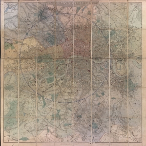
| Título: | Davie's new map of the British metropolis : the boundaries of the boroughs, county court, ditricts, railways and modern improvements. |
| Autor/Colaborador: | Davies, Benjamin Rees |
| Data: | 1871 |
| Descrição: | col. |
| 98 x 97cm. dobrado para 20 x 13 cm | |
| Stanford Series of New Library Maps | |
| Escala gráfica de 2 milhas [=15, 3cm] | |
| Assuntos: | Ruas - Inglaterra - Londres - Mapas |
| Streets - England - London - Maps | |
| London (England) - Maps | |
| Londres (Inglaterra) - Mapas | |
| Coleção/Fonte: | Biblioteca Fluminense |
| Tipo: | Mapa |
| Idioma: | eng |
 Acessar o documento na Instituição de origem
Visualizar