- Página inicial
- →
- Biblioteca Digital Luso-Brasileira
- →
- BNDigital do Brasil
- →
- Ver item
JavaScript is disabled for your browser. Some features of this site may not work without it.
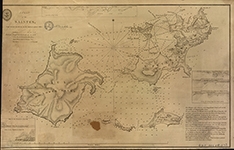
| Título: | A plan of the Saintes : from various documents in the Hydrographic Office |
| Autor/Colaborador: | Grã-Bretanha. Hydrographical Office |
| Data: | 1830 |
| Descrição: | Relevo em hachura |
| Inclui rosa dos ventos | |
| Escala gráfica de 2 milhas náuticas [=30cm] e "one mile or 1009 fathoms" | |
| Meridiano de origem: Greenwich | |
| Contém batimetria | |
| Encartes: 1 Leads between Wale Rock and Shoal - 2 Leads to the West d. of Wale Shoal & Fast a. of the Rock - 3 Leads between Rock B, and Cabrit Island - 4 When to the Eastward of Rock B - 5 When to the Westward of Rock B. | |
| litografado | |
| 29 x 46,7cm em f. 30,5x 47,5cm | |
| Assuntos: | Saintes Islands (Guadeloupe) - Maps |
| Saintes, Iles des (Pequenas Antilhas) - Mapas | |
| Tipo: | Mapa |
| Idioma: | eng |
 Acessar o documento na Instituição de origem
Visualizar