- Página inicial
- →
- Biblioteca Digital Luso-Brasileira
- →
- BNDigital do Brasil
- →
- Ver item
JavaScript is disabled for your browser. Some features of this site may not work without it.
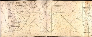
| Título: | A new chart from the Cape of Good Hope to the Islands of Madagascar, Mauritius,ec : shewing the Mozambique passages |
| Autor/Colaborador: | Norie, J. W. (John William), 1772-1843 |
| Data: | 1845] |
| Descrição: | 156 x 63,5cm |
| Meridiano de origem: Greenwich | |
| Encartes : Delagoa Bay - False Bay - Saldanha Bay - St. Augustine Bay - InhambanBay - Table Bay - Plettemberg Bay - Port Beaufort - Port Elizabeth - Knysna River | |
| Assuntos: | Coasts - Africa, Southern - Maps |
| Madagascar - Mapas | |
| Costa - África, Sul - Mapas | |
| Madagascar - Maps | |
| Moçambique, Canal de - Mapas | |
| Tipo: | Mapa |
| Idioma: | eng |
 Acessar o documento na Instituição de origem
Visualizar