JavaScript is disabled for your browser. Some features of this site may not work without it.
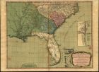
| Título: | A new and general map of the southern dominions belonging to the United States of America, viz. North Carolina, South Carolina, and Georgia with the bordering Indian countries, and the Spanish possessions of Louisiana and Florida |
| Data: | 12th May, 1794 |
| Descrição: | Monografia |
| Na margem lateral direita inserem-se: "Plan of Charlestown". Escala [ca 1:24000], determinada com o valor calculado 2,70 cm correspondente a "2100 Feet" e "Plan of St. Augustine". Escala [ca 1:16000], determinada com o valor calculado 2,50 cm correspondente a "Two Furlongs" | |
| Tipo: | material cartográfico, impresso |
| Material cartográfico ] | |
| Idioma: | Inglês |
 Acessar o documento na Instituição de origem
Visualizar