JavaScript is disabled for your browser. Some features of this site may not work without it.
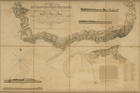
| Título: | <A> topographical chart of the entrance of the river Tagus, describing the coast from cape Roca to Sacavem; with the harbour and environs of Lisbon. The nautical is from a survey taken in 1806 |
| Autor/Colaborador: | Sousa, António Alberto Marinho Duarte de, 1896-1950 |
| Data: | 1810 |
| Descrição: | No canto superior direito representação de duas vistas: "View of Belem Town and Castle on the River Tagus", "The general appearance of the High Land the upper Port of which forms the Horizon, when in the Fair-way of the South Channel, with the Markes to avoid the Catchos, in turning between them" |
| No canto inferior esquerdo representação de duas vistas: "The Rock of LIsbon, Eastward 2 Leagues distant", "Appearance of the Rock of LIsbon and the High-land over Cape Espitchel; Cape Roxent bearing N.N.E. 1/2 E. by compass dist. 8 or 9 Leagues, & Cape Espitchel E. by S. 4 or 5 Leagues" | |
| Monografia | |
| Tipo: | Material cartográfico] |
| material textual, impresso | |
| Idioma: | Inglês |
 Acessar o documento na Instituição de origem
Visualizar