JavaScript is disabled for your browser. Some features of this site may not work without it.
| Título: | <A >new chart of the Cape Verde Islands |
| Data: | 1824 |
| Descrição: | Monografia |
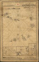
| Nas margens inserem-se 3 mapas e 4 perfis, a saber: Mapa 1:"Porto Grande in the Island of St. Vincent" . - Escala [ca 1:46000], determinada com o valor calculado 4,00 cm correspondente a "One Mile" matítima; Mapa 2: "Port Praya in the Isle of St. Jago". - Escala [ca 1:29000], determinada com o valor calculado 6,40 cm correspondente a "One Naytic Mile"; Mapa 3: "English road in the Island of Bonavista". - Escala [ca 1:74000], determinada com o valor calculado 2,50 cm correspondente a "One Mile" marítima. Perfil 1: «Appearance of the Island of Mayo in the morning bearing W by N. distant 5 or 6 leagues». - Perfil 2: «Appearance of the Island of Mayo highest mountain bearing N. W. 1/4 W. 4 leagues". - 3: «Appearance of South of the Island of St. Jago athe East point of Praya bay, bearing N.E. ¼ E. distant 2 leagues B. bearing N.E. 1/3 N. C. Tubaran point, taken in the morning». Perfil 4: «Appearance the Island of Mayo in the evening bearing N. E. 5 or 6 leagues» | |
| Tipo: | material cartográfico, impresso |
| Material cartográfico] | |
| Idioma: | Inglês |
 Acessar o documento na Instituição de origem
Visualizar