JavaScript is disabled for your browser. Some features of this site may not work without it.
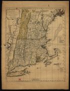
| Title: | A map of New England containing the provinces of Massachusets Bay and New Hampshire, with the colonies of Conecticut and Rhode Islands, divided into Counties & Townships |
| Author/Contributor: | Bennet, John, 17---1787 |
| Date: | [ca 1779] |
| Description: | Monografia |
| Data de publicação atribuída de acordo com as datas de colaboração entre Robert Sayer e John Bennet, 1774-1784, cf Tooley's dictionary of mapmakers, ed. rev. 1999, p. 119 (Bennet, John) | |
| Type: | material cartográfico, impresso |
| Material cartográfico] | |
| Language: | Inglês |
 Access the document in the institution of origin
Visualize